
There's an image of a heart-shaped honeycomb that's been floating around the internet recently, with a vague story attached about a French beekeeper who "forgot" to put a frame in his hive, so this is how the bees designed their hive.
This story tugs at the heartstrings. But it's not true.
A folklorist named Steve Byrne debunked the "beekeeper forgot to put the frame in" tall tale earlier this week. It's a fascinating read of how he traced the origins of the tall tale! Spoiler alert: turns out a South African beekeeper named Brian Fanner designed it as experimental art for his wife.
So today, I stick my nose into Twitter to discover that people are excoriating an "unknown designer" of a "transit map of the world." (Also on Twitter, click to enlarge, not linking to any specific tweet for reasons.)

"But what about my city, why did they ignore it? I want trains here too!" "Why does Africa only have five stops?" "Who the hell divided Japan up that way?" "What idiot wants a direct connection from Iran to Australia without stopping at India in between, their knowledge of geography sucks!"
Now, I'm a bit of a transit nerd. I know I've seen this map before, and have been seeing it online for at least the last decade. So I grab the retweeted image and head for TinEye to do some digging.
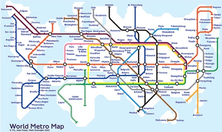
Calling this one Exhibit A. The earliest upload still accessible ("first found on Feb 7, 2008") has a (tiny, barely legible) caption: "World Metro Map, (c) TFL Alan Foale, Mark Ovenden 2003." 2003! Turns out, in 2003, Mark Ovenden published a book, Metro Maps of the World. His Wikipedia entry has more information about the various editions of that book that have been published since - the 2003 version was published in the UK; the first American edition (Transit Maps of the World) came out in 2007.

Exhibit B: The caption text on this one is mostly too small to read, but the legible text says, "Urban rail systems // Operating, under construction and planned 2008." So … this map might be referring to extant urban rail systems in aggregate somehow?

Exhibit C confirms this. Title: "Transit Maps of the World," as in the title of the American version of Ovenden's book. The caption confirms my hypothesis from Exhibit B; in part, it reads: "This playful diagram shows all the cities which have, are building, or planning to construct an urban rail system. It is the opening page of a new book about the graphic design of subway, metro, underground, and U-Bahn system maps and diagrams."
So this "transit map diagram" is based on early- to mid-2000s data of "all the cities that had, were building, or had significant plans to construct an urban rail system". If your city doesn't have a train system so people can get around within it, it wasn't within the scope of this map. Having an Amtrak station doesn't count. I admit I blinked when I saw Sacramento on the map; I did not know that Sacramento had light rail, even though it opened when I was in middle school and I lived all of two hours away. But it's a network of trains functioning as local transit, so it counts!
But wait, what about Alan Foale? Turns out he was involved with the design of the London Tube map at the time Ovenden was writing his book and making his map.

Looking at the map of the Tube, you'll notice the lines bear a strong resemblance to the lines that Ovenden used for his World Transit Map! Start by looking at South America - it's clearly the Heathrow loop on the Piccadilly line, which extends up the west coast of North America. Africa's been relegated to the District line and the "trams," under construction. The western Metropolitan line covers Canada and the Northern US; the eastern portion gets funky in Japan (nitpicking, but Tokyo and Kawasaki aren't that far apart, why is there a split here?)
But why is Africa drawn so small when we know it's the 2nd largest continent? Because subway maps are drawn to focus on making the system legible to the average rider, and they sacrifice 100% geographic accuracy in service of this goal. David Perell goes into more detail on this, referencing the history of the NYC and London subway maps and their local geography. The upshot: at the time Ovenden drew his original map (2003, remember), only five African cities had urban transit systems: Alexandria, Algiers, Cairo, Lagos, and Tunis. By contrast, the UK had 10 cities with urban transit systems; Europe as a whole had 93.
Ovenden updated his book in 2015, and yes, he updated his "map" as well to include more cities that had gained urban rail systems in the interim dozen years.

Especially Africa; additional cities with urban rail systems include Pretoria, Johannesburg, Durban, Cape Town, Port Harcourt, Santa Cruz de Tenerife, Casablanca, Rabat, Oran, Addis Ababa, and Constantine. Tokyo still hasn't been connected to Kawasaki on the map, though, which is silly given they're literally connected by two train lines which each run every 10 minutes and it takes 15 minutes.
Anyway, I now foist books on you all! You can buy Transit Maps of the World! Have Bookshop links to the 2015 updated version (it's even on sale, 10% off) and the 2007 American version.
Morals of the story: I *am* a transit nerd. Buy books from your local indie (and you can use Indiebound or Bookshop to find a local indie; ask the store whether they prefer you order directly or through Bookshop first, though, because survival business models differ in the pandemic times). And as Steve Byrne, the internet folklorist cited above concluded, "On the internet, search behind what you see. Don't take things at face value. Don't let your "aww" gene get in the way of thinking, hmm, is this for real?"
no subject
Date: 2020-06-19 16:13 (UTC)This, of course, is a terrible trait in a friend. 😂 Good trait in a librarian, but not a great social media friend.)
no subject
Date: 2020-06-19 17:18 (UTC)